Sunday 30 September 2018

The Church At Over

To understand the title of this post you need to know that there's a village in Cambridgeshire that goes by the unlikely name of Over, and that it has a very impressive church.


The village is poised on the very edge of the Fens, which was formerly a marshy area which was impassable to anyone but those with local knowledge in summer, and only navigable by boat in the winter months. There were small islands within the fen which were habitable and on the larger ones religious houses were founded in the early days of Christianity.


The isolation of these places must have had some appeal to these religious men and it also gave them a degree of protection from invading heathen armies - though not safety enough in many cases. Four great abbeys survived - at Ely, Ramsey, Thorney and Crowland - and during the medieval period they had enormous wealth and power, the monarch's forces having little control in this impenetrable watery landscape.


Around the edges  and on some of the islands within the fen there stand a number of magnificent churches. There are a number of reasons for this: 

Stone spires like the one at Over are rare in the rest of Cambridgeshire because the county has no appropriate stone for their construction. However an excellent building stone is quarried at Barnack, near Peterborough, which could be brought by boat to these fen edge villages.

Transporting stone and building huge churches was still an expensive business and, hard as it may be to imagine now, these villages were once wealthy places. When the fens were flooded and boats were small these places functioned as ports for much of East Anglia, which was wealthy too, through grain and wool production. The fens were also a great place for fishing and wildfowling which allowed the population to support itself even if the harvest failed.

Furthermore these parishes benefited from the patronage of the abbeys; in the case of Over from close ties with Ramsey.


And so you open the heavy door and find yourself in a large, well-kept church which once again proves that should you desire to make a church appear both grand and welcoming you could do a lot worse than invest in some red carpets and curtains!


The first thing to catch my eye was the pulpit which is Jacobean (early 17th century). Pulpits always look a bit strange to my eye but there is some science involved in their design: they are constructed to act as a soundboard so that the preacher's voice is naturally amplified so that all can hear.


The choir stalls are fitted with "misericords" which, you may remember from earlier posts, are small carved ledges fitted to  the tip-up seats. An ageing monk could perch his bottom thereupon to get a little rest from standing during long sermons. These seats are thought to have come from Ramsey Abbey when that establishment was closed down by Henry VIII. 


I can't tell you much about the stained glass, except that it's probably of no great age. However its always satisfying when such photos come out well, so I couldn't resist including it here.


As you look around you realise that there are carved faces everywhere - you are being watched! There are lots more details - a nice font, a medieval rood screen, boards telling of the feats of the bell-ringers, a marble slab recording the deaths of a married couple within a few days of each other in 1676....


Outside, through the porch (which everyone says is perfectly proportioned, but looks a bit top-heavy to my eye) I realised I was still being watched....


....not only watched but being rudely attacked! Over church has some inventive gargoyles to funnel rainwater down onto the unsuspecting.


Above a door in the tower is this medieval representation of the Virgin Mary. One that the puritan iconoclasts must have missed.


As I left the churchyard I met a man who was very enthusiastic about his local church "Some of the best gargoyles this side of Notre Dame!" he told me. He was delighted to learn that I had just been photographing them. At this time of year it also has one of the finest displays of cyclamen hereabouts.


Take care.


Friday 28 September 2018

More From The Hills


Last time I showed you my walk through part of the eastern extremity of the Chiltern Hills, which included the spectacular views from the Pegsdon Hills, Deacon Hill and Knocking Hoe. Needless to say such a location, in such crystal clear weather, induced a frenzy of shutter-clicking. So here are a few more photos of that day, interspersed with more or less random thoughts.


When our medieval ancestors had any sort of dispute they called a meeting to thrash out their differences. They had a building specially for the purpose, it was called a Moot Hall. The word "moot" exists today only in the phrase a "moot point", meaning something which is in doubt and needs debate. Before they had Moot Halls people had the curious habit of calling such meetings on hill tops, moot hills. Since most of their disputes were about land ownership this makes perfect sense; in a time with no accurate maps, from up here you could simply point to the lands, boundaries or tracks which were being discussed.


The Chilterns are named after the Cilternsaete, who were an early tribe who inhabited this area, probably living in the valleys along the northern edge and grazing their animals and also burying their dead on the higher land. Before the Romans came building their roads across the country, the top of this ridge provided the safest and easiest way across the country but by the medieval period things had reversed and these hills provided a refuge for bands of robbers and outlaws.


On top of Deacon Hill stands this concrete pillar which is a remnant from the map-making activities of the Ordnance Survey. From the top of the pillar they would take bearings onto all the prominent landmarks, then they would transfer their activities to other hill tops, which were a known distance away. By taking bearings from these other points they could then painstakingly calculate the exact position of every feature of the landscape in order to make their maps. Nowadays these pillars are redundant as aerial photography and satellite-mapping have taken their place.


Lilley Hoo, the wide ridge by which I approached this area was once a racecourse for horses and King Geoge IV and other rich and noble people were known to attend. There's still a lot of horse-riding in the area today, though of a rather more sedate nature.


Robin Andrea asked via a comment about our English footpaths and how come we can walk about on private land. Very briefly, in past centuries when most people travelled everywhere on foot there was a dense network of tracks and paths. Although there have been many changes of land use since those times, English law upholds the right of all citizens to wander where they have "since time immemorial". Thus there are "rights of way" which traverse all kinds of land - moorland, agricultural land, meadows, woods, forests, clifftops, even sometimes across people's gardens. I wrote a bit about it back in 2014 and I'm gradually collecting photos for another look at our footpath heritage which I might put together on some long winter's evening.


A convenient seat for an old chap like me to sit down. I like to think I'm still about 25 but the birth certificate disagrees and I find myself a gentleman of leisure. Increasingly I receive appropriate little acts of kindness from the general public - doors are held open, bus drivers wait for me to be seated before they move off, and if I take anything back to a shop I'm listened to with patience and understanding. Quite why we can't behave like this to everyone all the time I'm not sure. The irony is that I used to be a hard-working member of society doing a very necessary job, whereas now I'm a sort of idle parasite living off a pension. I think I'll sit down for a while anyway.


I've been thinking about that heap of rubbish we saw that was rather spoiling the landscape at one point in my walk. Looking at the map it's too far from a road to be fly-tipping - though there's certainly plenty of that around the countryside. This seems to have been dragged there perhaps by the owner of the land. I would be tempted, on reflection, to think they might be going to set fire to it, except that there's a toilet included.


As I walked from the village of Lilley
The weather was sunny but chilly
If you followed the path
For nine miles and a half
You'll find it decidedly hilly.


Take care.


Tuesday 25 September 2018

Hilly Lilley


Monday's walk started at the village of Lilley in Hertfordshire. It wasn't till recently that I realised that it was served by a bus service and therefore opened up new possibilities for walks. 


A short sharp climb from the village led up onto the ridge known as Lilley Hoo. It was pleasant enough walking but views were largely blocked by hedges and plantations till I reached Telegraph Hill. The name is nothing to do with modern communications but dates back to the Napoleonic Wars when it was part of a network of signalling stations across the country. Men were stationed atop prominent viewpoints and passed messages from hilltop to hilltop with astonishing speed - as long as it wasn't foggy!


We're now in the Chiltern Hills, or at least an outlier of them. Most people know the Chilterns in Wiltshire, Oxfordshire and Bedfordshire, bit few realise there's this little bit to the east of Luton. The whole ridge is formed of chalk which is composed of microscopic marine life which died and sank to the bottom of ancient seas some 65 to 95 million years ago. We should get some super views once we've passed through this beech wood.


This little section is Pegsdon Hill. Quite apart from the views it's also rich with wildlife, especially during summer when there are many orchids and butterflies to be seen. Expect a visit here next year!


It's easy walking along the top and was used as a major routeway by Iron Age people making their way across the country. We don't know if they had a name for it but at some time it became known as the Icknield Way.


This is one of the best places in the country to see birds of prey. Red Kites and Buzzards, which were once noteworthy sightings, are now common along the ridge. The sight of 50 to 60 birds, all Kites and Buzzards, wheeling around in the blue sky, was just one of the rewards of my walk.


There are many ways to read a map. With practice you can almost envisage the landscape from a detailed map, but how about reading it as poetry? Place names on today's map include: Mazebeard Spring, Tingley Wood, Brogsdell, Cloudhill Farm, Muzzleford Wood and Knocking Hoe.


That's Tingley Wood....


And here's Knocking Hoe, a dry valley which also has interesting plant life in spring.


The rest of the walk, undertaken in perfect conditions for walking, would have seemed splendid if not for comparison with what had gone earlier.


The only sight marring the prospect was this heap of rubbish left inexplicably in the middle of a pretty meadow. Why?


Finally I made my way by Lilleyhoo Lane - now there's a name - then over the hill back to Lilley. ("Lilley in the valley" you might say!)


Take care.  

Sunday 23 September 2018

Vane Glorious

A selection of prettifying prognosticators from the rooftops of East Anglia. Like all good meteorologists there are considerable differences of opinion as to just which way the wind is blowing....


Take care.


Friday 21 September 2018

Windy Corners


It was a windy Wednesday. Not a deadly or destructive wind, but a blustery, boisterous one that pushed you a little off-balance at every step and threatened to deposit your hat in the nearest hawthorn bush. We were walking, my brother and I, in the vicinity of Bartlow and Ashdon, which hide in the SE extremity of Cambridgeshire and the NW corner of Essex respectively.


Just a few minutes into the walk and already I'd rather mislaid the footpath in a decaying farmyard full of wonderful old machinery. We scurried somewhat guiltily through and, by a combination of reading the map and tossing a coin, managed to locate our route once more.


It lead us through gaps in hedges, down abandoned lanes, over little footbridges and around and over recently harvested fields.


A Buzzard circled overhead and whole squadrons of Red-Legged Partridges took off from the base of a hedge, where they'd been feeding on berries dislodged by the mechanical flail used to bash the hedgerows into shape. These Partridges are not really wild birds but are raised simply for the pleasure that some people get from blasting away at them with guns.


Eventually we found ourselves descending, sheltered from the wind at last, towards the village of Bartlow.


Bartlow Church has a round tower, something which is common enough in Norfolk and Suffolk, but a rarity as far west as this. There are all kinds of mad theories as to why towers are built in this fashion, but it's probably because there's a lack of good building stone in Eastern England, which would be required for making corners. Round towers could thus be built from flint and field stones.


I'd been inside before but I'm glad I made a return visit as the medieval wall painting of St Christopher appears to have been cleaned up and restored since I was last here. A lot more detail is now visible.


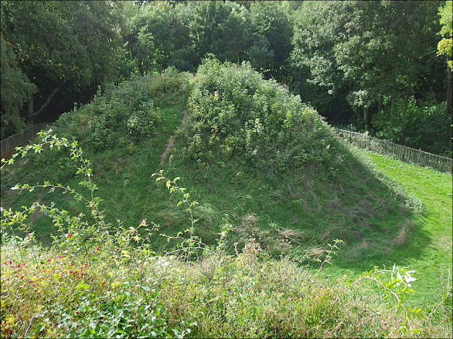
From the church a narrow fenced path leads down to one of England's least known treasures. Here stand three Romano-British burial mounds dating from about 100 AD. They are the highest such mounds in Northern Europe standing about 13m (40 ft) high. There were once seven mounds but four were destroyed when the railway was built nearby. When they were excavated they were found to contain grave goods and cremation urns. This blog has been there before and you can read more about it here
http://bystargooseandhanglands.blogspot.com/2011/10/three-secrets-three-wonders.html
where you can also see what St Christopher looked like before restoration.


Off we went over the fields once more towards Ashdon, which is a very straggly settlement with lots of associated hamlets called "Ends".


Crossing another field brought us beneath the huge sails of Ashdon windmill. The old timers knew what they were doing when they sited the mill here; it was quite the windiest spot on the entire walk.


Our chosen route crossed the village street next to this magnificent old house which dates from the 16th or 17th century. It appears to be unusually tall for a building of this vintage.


I didn't spend long inspecting the church, but can't resist showing you these wonderful flowers which I presume must have been left over from a weekend wedding.


Take care.