Sunday, 16 August 2015

The Old Way

Roads and pathways obviously connect one place to another, but also they connect us through time with those who travelled this way before. How long before? Well, who knows , for once a track is established it's difficult to imagine why people would abandon it and set about making a new path.


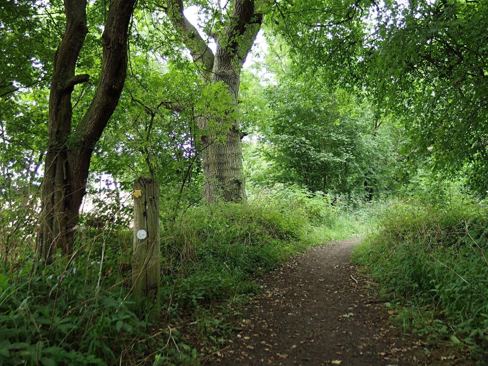
I've been walking a leafy track near my home. It leads from the village, crosses the busy modern road, passes a big house called Melbourn Bury, then shortly afterwards it peters out, but seems to be heading in the direction of the Bronze Age burial mound on Greenlow Hill and on towards the chalk ridge beyond.


This row of chalk hills stretches, with a few gaps, from the south coast in Dorset right up to the North Norfolk coast. England's oldest road The Icknield Way followed the crest of these hills because, it used to be thought, everywhere else was thickly forested. Early archaeologists found much to interest them on these bare hills and concluded that this relatively treeless land was easier to settle than the wooded land to the north.


They'd forgotten one important thing - water. And there's very little surface water up on the chalk hills.  Water is not only essential for everyday life, it's also heavy and awkward to transport, especially uphill! It seems likely that people would have lived near to a source of water, such as the clear springs which issue forth from the base of the hills.


Although they may have grazed their animals and buried their dead high up on the hill, they probably lived lower down. What's more we're now not so certain that the lowland forests were quite as continuous and impenetrable as we once believed so they may have used this land too. It seems probable that some sort of track would exist between the hills and the village at the spring and perhaps leading on into the woodland.


Now that big house, Melbourn Bury, was built in the mid-nineteenth century, but on the site of a medieval dwelling. Close by is the source of the little River Mel that flows through my village. Whoever lived in the area at any time in the past would have been attracted to it as a source of pure spring water. So is it too fanciful to believe that people have lived here for even longer, stretching back deep into history?


And those people would have needed a track to lead up to their grazing lands and perhaps towards the more wooded area too. They'd have walked up to their herds and perhaps brought the animals down daily to drink. They'd have gone north into the woods to gather berries and firewood as well as hunting trips. 


If this assumption is true then could this track which I'm walking lead us all the way back, past the Bury, past the Bronze Age tumulus and right back to the first people who settled this land. In other words did men, women and children from the Old Stone Age tread this same path I'm walking today?


Take care.


Friday, 14 August 2015

Cottage Pie

Whenever I show you pictures of the thatched houses, of which there are many remaining in the villages around here, I get lots of interested comments. So here is a collection of pretty homes for those who wish to dwell deep in a dream of Olde England. (With apologies to at least one regular reader who will say "Yuk! Too twee by far!").


So what is a cottage? Well, not necessarily what I'm showing you here! The Domesday Book mentions "cotters" which were that class of people who lived in homes with a small amount of ground, enough to just about sustain a small family. These were poor people and were often worse off than serfs, who were themselves little more than slaves.


Over the centuries the cotters, or cottagers, could do little to improve their lot and, despite them being the bedrock of the economy, the rest of society did little to help them either. The homes in which they lived were mostly little more than huts; the word "cott" actually meant a hut for livestock originally. It was only the romantic poets who appropriated the word to mean a cosy, idyllic rural homestead.  


Unsurprisingly very few of the hovels that the true cottagers lived in survive. The buildings I'm showing you here would have been the homes of small farmers or tradesmen, though some are the houses which wealthy landowners constructed in traditional style for their workers during the eighteenth and nineteenth centuries.


Another definition of "cottage" is "a small, rural house of traditonal style". This raises the question of "what is traditional style?" It would of course vary across the country depending on what building materials were available locally. So it doesn't have to have a thatched roof at all; it could be of slate, tile or even turf. Around here it just happens that thatch, either of straw or reed, is the cheapest and most plentiful material.


In this area you can't usually see how the walls were constructed because they are generally covered in some sort of plaster. Underneath there's usually a wooden frame which is infilled with woven willow to which the plaster adheres. It's called "wattle and daub" and sometimes the wooden beams are left showing which again is "the essence of Olde England".


Another feature of the cottages around here is that the upper storey, which is where the bedrooms are, is at least partly in the roof-space. In the oldest examples it's been shown that initially there were no such things as bedrooms, just a platform reached by a ladder. Proper floors were a later innovation and were inserted afterwards. This leads to many odd steps and low beams in some old cottages.


I can speak with some authority and feeling about the architecture of one cottage in particular as a friend of mine lived in it. All his family were short people but I was seldom able to visit without one or two painful blows to the head from low beams.


Fashions changed over the centuries too. All the stone-built cottages in the English Lake District were once left their natural colour. By Wordsworth's day people had started painting them white, much to the annoyance and dismay of the poet who campaigned against this ghastly practice. Strange then that today nearly every visitor to the area remarks on the delightful white-painted cottages. 


Meanwhile, down here in England's deep south, sometimes the whitewash was coloured pink by the addition of ox-blood. Though I don't think they were ever quite such a shocking shade as the one above!


Take care.


Tuesday, 11 August 2015

Unexpected Items In Blogging Area

A number of peculiar and puzzling things that I've collected in my wonky-wheeled trolley as I travel up and down the tempting displays in life's supermarket. I'm afraid to say that I'm the equivalent of the person who stops to read the ingredients and the consumer information on things they don't really want, blocking up the aisles and wasting everybody's time - much as I'm wasting yours right now.


Take Two Signs


The county boundary between Cambridgeshire and Suffolk performs some remarkable contortions, one of which is to divide the twin villages of Kennett and Kentford so that the former is in Cambridgeshire while the latter swears allegiance to Suffolk. This is odd, to say the least, since the two villages join up to form one settlement. They are so close to each other that the two village signs above are actually opposite sides of the same board!


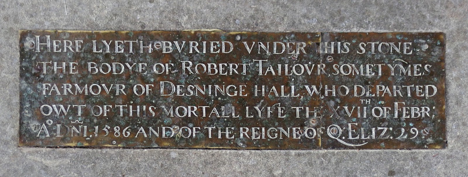
Owt Of This Mortall Lyfe

Centuries ago it was common for the more wealthy parishioners to be buried in the body of the church and commemorated by brass plates attached to huge marble slabs set into the floor. Usually nowadays the brass plaques are missing, most often due to the attentions of metal thieves rather than Puritanical zeal. Somehow this one has survived for nearly 430 years. 


Wartime Refugees


It was not only children who were evacuated from London during the war years. The building above, which is in Cambridge's Trumpington Street, housed The London School Of Economics from 1939 to 1945 at the invitation of the master and fellows of Peterhouse College.


Changing Times


In my student days, back in the early 1970s, the words "student" and "haircut" seldom appeared together!


Bar-Room Stationery


...or beer mats as they are sometimes called. I used to have a splendid collection of these, advertising many brews and breweries that have long disappeared. Lots of people collected them, sneaking an odd little cardboard coaster into their pockets as they left the pub. I discovered that it was a much better tactic to go and ask if I could take a beer-mat for my collection. I was never refused and, often as not, I was given a stack of other mats which the pub no longer needed. The hobby faded as so many breweries closed down or were absorbed by the larger companies. Nowadays the increase in small specialist  breweries has made it interesting again. I wish I hadn't thrown all mine away.


A Mystery


High up on a wall in Cambridge, above a modern shop selling chocolate, is this ornate stone. It bears the crest of nearby Emmanuel College along with the words "The Chalice". But what was The Chalice? What's the connection with Emmanuel College? Why is it high up on the wall of this building? I don't know and can't find out.


Pet Hates


If there's one thing I can't stand it's the little resin animals with which people decorate their gardens at huge cost. But these two, spotted in Kentford, where we began today's ramble, are the exception to the rule. Ahhhh! 


Take care.


Sunday, 9 August 2015

Borderlands

Today we're headed just over the county boundary into Suffolk. We'll visit three villages and, unsurprisingly, three churches, but it's far too nice a day to spend much time indoors when the scenery's like this....


...but first I had to do a little road walking, though the wild flowers kept me company throughout.


The first village was Gazeley with its large church at the heart of the community. Rather too large a church it appears, as the parish is constantly struggling to keep the fabric of the building intact, not least because so much of both the church and its contents is so old. 


The village itself is pleasant enough though not as perfectly picturesque as the other two on our route.


From Gazeley we can pick up a section of the Icknield Way Trail, a modern approximation of the ancient route, which steers the walker away from roads to visit the most interesting sites and tranquil landscapes. It's also waymarked with little signs fixed to gateposts which saved me looking at the map too often.

The path led through agricultural land before diving unexpectedly into a wood.


There were occasional glimpses through the trees out on to the newly harvested fields. These huge square bales are increasingly common these days. 


An occasional exotic tree was seen by the path and paddocks occupied by fine horses could be glimpsed through the bushes. As I suspected, I was getting near to Dalham Hall. The church appeared first, then the hall itself. It was built in the early years of the eighteenth century by the then Bishop of Ely. It is now owned by Sheik Mohammed bin Rashid Al Maktoum, the Emir of Dubai and the Prime Minister of the UAE, but who's probably better known in these parts as one of the world's leading race-horse owners.


An avenue of trees led me down to Dalham village, one of the lesser-known of Suffolk's many beautiful villages. Impossibly pretty cottages line the street which follows the course of the little River Kennett. 


But there's also a relic of the village's industrial past standing by the roadside...


It's a kiln that was used in the nineteenth century for drying malted grain for use in beer-making. Nearly every village would have had a malting kiln at one time but they have mostly disappeared now. This one looks to be in remarkably good condition.


Then it was time to find the footpath, running parallel to the course of the River Kennett, to complete the final leg of the journey to the village of Moulton,.


Now you might think the picture above is of the path, but no, this is the bed of the river which is dry at this time of year. You could walk along it,of course....now there's an idea....I've never walked along a river bed before......I wonder....


It was good walking for a start, but then I found myself pushing through increasingly dense vegetation and eventually water started to appear. I had to scramble up the steep bank, through the nettles and brambles, over a fence and back on to the path that I should have been following all along.


At length I arrived, a little scratched and stung, in Moulton where the church has a weather-vane in the shape of a large fish, possibly because this is St Peter's and he's the patron saint of fishermen. Whatever the reasoning behind it, a fish looks completely ridiculous stuck up on top of a tower. But Moulton is far more famous as the site of...


....a Medieval pack-horse bridge. Before the Cambridge-Bury St Edmunds-Ipswich railway line and the busy A14 road were built travellers and carriers passed through Moulton and needed to cross the River Kennett. The water level is not always as low as it is in mid-summer; at times the river can flood, so a bridge must have been a worthwhile investment. Although similar bridges are fairly common in some parts of the country, East Anglia has very few.

And that's the end of my walk.......Take care.


Thursday, 6 August 2015

Plenty Of Colour

We've been to Bressingham Gardens before and you can see those posts here and here. But when I went yesterday I just concentrated on the marvellous colour. 


The gardens were started by the horticulturalist Alan Bloom - what better name could there be for a gardener than Mr Bloom?


Take care.


Tuesday, 4 August 2015

Once Upon A River

I spent much of my teenage years, ("too much", my schoolteachers might have said), messing about in a punt on the River Cam. I always had at least one pair of shoes drying out and my jeans permanently had the smell of the river hanging about them.


We found an old punt that was riddled with holes skulking forlornly in the river and decided to drag it out of the water and renovate it. We effected our repairs with metal plates, bits of plywood, baler twine and copious quantities of black, sticky pitch. (Add the smell of pitch to my fragrant old jeans).


But somehow it held the water out....well most of it anyway. Just in case you ever need to know, the ideal implement for bailing out a leaky punt is the humble plastic dustpan. Works a treat! 


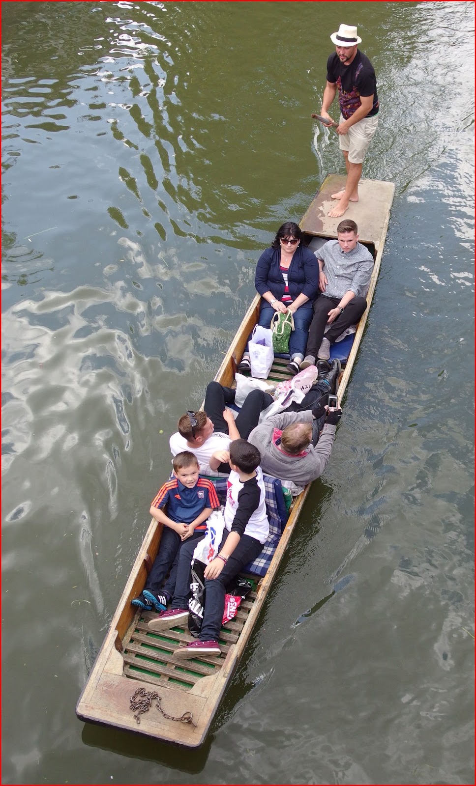
Then of, course, we had to learn the techniques and tricks of propelling a long, awkward boat with a long, awkward pole. Our early efforts were not pretty to behold, but we improved with practice, to the point where we felt we'd earned the right to mock, ridicule and generally insult all those who were less skilful than us. And, certainly at the beginning of the punting season, that included most of the students who'd newly arrived at the University. Every year a new intake of intellectuals learned one of life's important lessons...


....it's harder than it looks. For those who want to know, the beginner's way to do it is thus:
stand on the back of the boat; put the pole into the water alongside the punt, push the boat forward, leave the pole dragging in the water and use it as a rudder to straighten your course. Easy, isn't it? The steering bit obviously loses you momentum so when you get good you can keep on course by subtly altering the way you push on the pole - it's called "pulling and pinching". Honest.


The inexperienced boatman, though,  would end up bouncing along from one bank to the other, while the object of their affections was forced to use the paddle to push the boat out of overhanging bushes or off from the muddy banks. Furthermore they might well have been entertained by one of my witty friends putting on a "posh boy" voice and bellowing "Oh, how quaint, Cyril, someone is operating a ferry service!"


It is no surprise to learn that a society exists within the University which is known as The Dampers' Club and is open to all those who have unintentionally entered the River Cam fully-clothed.


Anyone visiting Cambridge and anxious not to become immersed in the limpid waters of the Cam might be interested to hear that chauffeured punts are available for hire which will transport you safely and effortlessly past the historic buildings and even provide a commentary on the journey. Don't be a cheapskate: do it in style!


Most printed sources claim that punts originated on the Thames, however most of the old men in our village told us that punts came from the Fens where they were used for wildfowling, fishing and setting eel-traps. I also heard that they made their first appearance in my home village of Grantchester transporting churns of milk downriver to Cambridge. 


One summer's evening my friend Salty and I decided to see how quickly we could get down the river to Cambridge. To do this we equipped ourselves with two punt poles and punted in tandem. In my memory we did it in thirty-five minutes, though our time may have improved with frequent retelling. We then moored up and had a few beers in The Mill pub before returning rather more slowly and erratically back up the river in total darkness.


However most of our expeditions were more leisurely; fishing in the millpond, slopping along gently to a soundtrack of guitar and harmonica music, mooring up under an old willow tree and drinking cider or drifting downstream on a Sunday morning watching the wildlife. And usually we remembered to.....

take care!